Wednesday 30 September 2009

Yellowstone Park


Approaching the main geyser area of the park was like driving into a wartime film set. Plumes of smoke rising into the bright morning sun.
Hugh volcanic eruptions have taken place in the area and much of the park sits in the "Caldera" (crater) of the last one (600,000 years ago).
The area has over 10,000 geothermal features as the earths crust is only 3-6 miles thick compared to a normal area thickness of around 30 miles.


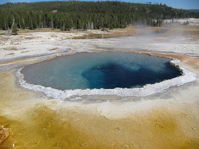
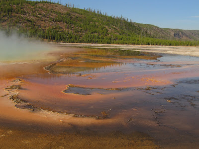
Clear blue, near boiling water in many pools has coloured edges caused by bacterial growths which are adapted to the high temperature and a diet rich in sulphur and iron.


Geysers bubble and spray at the side of the path. Some are regular performers, others sit quietly for days, months or years before they erupt. This is Sawmill Geyser, a playful little chap that gave Elaine a thorough soaking. We walked past again an hour later and all of the water had drained down from the mouth.

Probably the best known geyser in Yellowstone "Old Faithful", so named because it erupts every 90 minutes or so to a height of 150ft ft or more.

In the north-east of the park is the Canyon area. The Yellowstone River has carved an impressive 27 mile long canyon that is up to 1,200ft deep through the rock.


In the north-west is a different type of formation. Mineral laden water is pushed into pools where evaporation has caused multi layered rock (called Travertine) to build up in huge terraces.


The large pool sits on the edge of the formation with views towards the distant mountains.


Caverns and bones


In southern Montana we took a tour of the Lewis and Clark Caverns. These two explorers passed through the area years before the caverns were discovered and were totally unaware of the formations hidden within the mountains.


The 2 hour tour took us down 627 steps to various "rooms" full of weird shapes and forms. The tower on the left of the picture is 30 ft tall.


Museum of the Rockies is home to hundreds of dinosaur bones found in the area. Part of the University of Montana the museum claims to be one of the leading centres for paleontology and has many active research projects.
(Elaine in discussion with a learned old timer at the museum).


This recreation of a small (veloceraptor type) dinosaur attacking a much larger herbivore shown what they believe they looked like. Most closely related to modern birds with their lung structure and hollow cell bones some also had feathers.

Friday 25 September 2009

Lake County, Montana


About 50 miles south of the US border we entered Lake County and drove down highway 83, between mountain ranges on each side with the river and lakes along the valley bottom.

Our stop for the night was Tamaracks, Seeley Lake.

Facing west looking across the lake there were spectacular sunsets.


Next morning I got up and braved the almost freezing temperatures to catch the mist rising over the lake.


Painted Turtles


Kikomun Creek Provincial Park in south-east BC is one of the few areas where Painted Turtles live in Canada.


These are 10-12" long and doing what they are supposed to do - basking in the sun - not hiding from the camera!!


They get their name from the yellow and red colouring.


It was our last night in BC and we had to get rid of our stash of fire wood before crossing into Montana.

Tuesday 22 September 2009

Southern Alberta


Fort MacLeod was the first fort set up by the North-West Mounted Police (NWMP) in the 1870s. Sent west to bring law and order to an area plagued by whiskey trading and outlaws the NWMP later became "The Mounties". The original force was about 270 strong initially but gained a widely known reputation.


The area around Fort MacLeod is still fairly flat and we headed west again towards the more southern part of the Rockies and Peter Loughheed Provincial Park.

Mountains and lake in the Park.


Despite it being Mid- September, Elaine got a touch of spring fever and had a little dance in the creek.


A little further downstream and it was very tranquil.


Hay bales stretched for miles as we travelled down highway 22.


On our last day in Alberta we saw real cowboys on horses hearding cattle!!

Thursday 10 September 2009

Lethbridge

Lethbridge is the largest community south of Calgary, 100 miles to the north. The city of
80, 000 serves the local grain producing farms and has its heritage in coal mining and railways. There are several parks and green areas which make a pleasant change to the undulating (wheat yellow) paraires that extend for many miles in all directions


The Nikka Yuko Japanese Garden near the town centre was established in 1967.

The head gardener visits from Seattle each month and gives instructions.

The garden blends into the adjacent Henderson Lake Park.

Railway nerds time again.
Lethbridge is the site of the worlds longest and highest railway viaduct. Completed in 1909 it is around a mile long, 100m high and carries modern trains weighing up to 16,000 tons.


Train heading over the viaduct.


South west Alberta


Waterton National Park spans theborder between Canada and the USA. In the USA it is known as the Glacier National Park.


We only spent Thursday night here as it was a holiday weekend and the campground was fully booked.


The day had been windy and gusting winds (40+mph) remainded through the night; not so gently rocking us to sleep!!


Cameron Falls at Waterton exposes some of the oldest rocks, estimated to be 1.5 billion years old, in the Canadian Rockies.


Nearby Payne Lake as the evening sun goes down. Amazing cloud formations.


The colours intensify as the sun drops lower in the sky.


A power cable pole makes an ideal picnic table for the local Ospery.


Calgary


Our trip back to the UK involved flights from and back to Calgary. We had an overnight stay in the city on the return leg and a look round before heading back to Radium on the Greyhound coach via Banff.


During the day it was a busy city with traffic and people in the downtown area - quite a contrast to the evening before when most streets were deserted with the exception of one stretch of about 200m where all the major pubs and restraunts were located.


This is the view from our hotel balcony.
One of the green spaces surrounded by skyscrappers in the downtown area.
The Calgary Tower is not particularly tall at 191m (627ft) but walking on the plate glass floor is still un-nerving.
Elaine put her toes on and that was the limit although she did ask if my life insurance was fully paid up!


Banff railway station in the evening. Also the Greyhound stopping point in the town.

Unexpected trip back to the UK

On 2nd August we had the sad news that Elaines' mum had died and we returned to the UK for 3 weeks.

Columbia Valley


My 55th birthday was spent at a RV park on the shores of Lake Kinbasket, where the Columbia River has been dammed and create a lake that is 144 miles long.


Further south is Radium, famous for its hot springs and big horn sheep.


The Columbia River wetland area upstream of Lake Kinbasket.


Lake Windermere at Ivermere is popular for watersports. The names though familiar to us are very confusing as you go through a number of well known "British" locations but the are all in the wrong place.

Wednesday 9 September 2009

Yoho National Park and Spiral Tunnels

OK so this is a bit of a one for railway nerds. The mountain pass was too steep for running normal trains, so to avoid the need to split the train and use additional engines they made the slope more gentle. In 1907 a pair of tunnels where the entrances and exits overlap were built. Known as the Spirral Tunnels they took 20 months to build.

As front ofthe train leaves the exit of the tunnel the rear is still crossing the pass andwill shortly be disappearing into the entrance of the same tunnel.


Further down the Valley in Yoho National Park is Emerald Lake.

The Kicking Horse River.


A typical section of road. The rock faces are highly unstable and the verge littered with fallen stones.

Oh, it is Highway 1 - the Trans Canadian Highway.