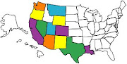
Having spent Christmas and New Year in the UK we arrived back in Phoenix, AZ on 25th February 2010. After a few days near Buckeye, with Helen and Peter O’Grady from Shotley Bridge as guides and hosts to the area, we were over jet lag and ready to move on. Final preparations were getting a 15,000 mile vehicle service and generator oil filter change completed. By the end of the month we will have travelled across southern Arizona, through New Mexico and reached the west side of Texas. You can follow the route on the map (032010) at the side.


Organ Pipe Cactus National Monument
First stop was OPCNM, the only area in the US where this particular type of cactus grows, although it is fairly common in Mexico (about 5 miles south).


We took advantage of a mini-bus tour into the nearby mountains to see areas which were inaccessible to our RV and attended a night talk by one of the rangers (about the stars and what they meant to the native people) presented in the open air amphitheatre in almost total darkness.


Naturally formed arch, the opening is 90wide and 36ft high, formed by weather erosion. Eventually the arch will collapse leaving only the peaks.

The image of a bulls head and horns, which are 500ft wide, give the name “Longhorn Rock” to this formation.

Taking it easy at OPCNM.
Kitt Peak National Observatory
On the road to Kartchner Caverns, our next stopping place, we took a detour to Kitt Peak. One of the major optical astronomy sites in the US there are numerous telescopes perched high above the dessert south of Tucson.


Most are used for viewing the night sky, although one of the largest structures on the site ,over 500ft long, is a solar telescope (left and above left).
Kartchner Caverns

Discovered in 1974, the caverns remained a closely guarded secret until 1988.
Following eleven years of preparation they were opened for public viewing in 1999.
These caverns are very “live” with a large number of the features still active and wet. Walkways are designed to contain dust and every night a team of cleaners goes through to vacuum any dust or fluff that may have been bought in by visitors. To maintain the 99% humidity and help keep the caverns clean visitors walk through, double air locks and a misting tunnel to damp them down.

Tours accommodate around 700 people a day visit the caverns and if you don’t book ahead (we didn’t) you have to join the queue for remaining tickets at 07:30am in the morning to try and get a place (we did).
Photography is not allowed in the caverns, so pictures are copies of cards available from the site.
Patagonia State Park, AZ
Recommended by Laurie and Monica, who we meet at Zion Canyon in October 2009, Patagonia State Park is an extremely rare splash of colour and water in the dessert. Based around a man made lake wildlife and people congregate along its’ shores.


that is until the 1930s when the lake was formed.

In the early hours there may have been the gurgling of a steam engine passing deep below the surface of the waters.
Then again it could just have been a duck having an early morning dabble……..you decide!!
Bisbee - Rooted in the 1960s
The south-eastern corner of Arizona was, and remains, a major source of copper. The old mine at Bisbee closed many years ago and is now open for tours where ex-miners take visitors through tunnels on the underground railway.


The old town of Bisbee sits high in the hills and its’ former wealth can be judged by the number of fine building that exist.


Now a tourist destination the town was popular in the 1960s with people looking for alternative lifestyles –

evidence of which can be seen in a number of places.


To the east of the old town the scars of a newer surface copper mine can be seen and nearby there is a huge hole in the ground. This is one of several such mines that operate in this area.

A new venture in the town is the “Old Bisbee Brewing Co.” Keen to support the local economy we visited on the first day of business and enjoyed the first of their stout and red ale brews.
Even “she who does not drink beer” admitted that the red ale was pretty good.

Two pints of stout put a smile on my face……. and gave Elaine a quiet afternoon.


As we chatted to the “barmaid” a young lady called Mindy Winquist, , who is also General Manager and Brewer, we discovered that she did her brewery training in Sunderland, UK, only a few miles from our home.
Into New Mexico

We took our leave of Arizona across HW78 which twisted and turned up into the mountains and lead to the high mountain pine woodland.

Our first view of New Mexico.

In several places the “River” runs across the road. This time of year it is from snow melting on the higher ground. The wettest month is July. Signs warn of flash flooding.
Rockhound State Park

In most State Parks the rules advise that wood, plants, rocks etc. are part of the natural landscape and that they are not to be removed or interfered with in any way.

This park is different!!
The area is noted for the semi precious stone Jasper and geodes (rocks containing crystals) can be found in the hills within the park. In addition to providing information about the rocks and the areas to find them they are happy for each person to take 15lbs of rock away with them.

We walked the trails and picked up and examined a few bits of rock on the way …….
and decided we had no need for any more than a couple of small pieces of Jasper to remind us of our visit.
Rio Grande Valley
The major river in New Mexico is the Rio Grande and its’ valley provided a route north to Albuquerque that we felt may be interesting. Further south it forms the border with Mexico.
Our first stop was in Las Cruces and we visited the historic town of Mesilla which is now one of its’ suburbs.

The jail where Billy the Kid was first tried for murder now houses a memorabilia store.
“The Kid” escaped from so many jails that several towns make claim that he was arrested and spent time in their lock up.

On the opposite corner a further store claims to be the oldest brick structure in New Mexico. The plaque showing its’ history reads like a murder novel.
Ownership changed every couple of years usually due to the owners being murdered, eventually it passed to a Frenchman who wisely stayed in France and survived.

A drive through pecan groves led to Caballo Lake, one of the many reservoirs on the Rio Grande, then after an overnight stop, to Elephant Butte Lake, the largest of them.
Sunrise over Elephant Butte

Avoiding the snow
A forecast of high winds, heavy rains and snow for the north of the State led to us deciding to head east for the Valley of Fires State Rec. Area.

Our next stop was Three River Petroglyph Site, a little further south. 
The nearest habitation is 40 miles further down the road, but for 60 miles north, east or west, apart from the occasional shack there are very few people.


The meaning of the images on the rocks, who made them and why, is not known however, with 20, 000 examples in the vicinity it is considered that there must have been a significant population at one time.


Our next stop was in the town of Alamogordo, which serves the local air force base, and White Sands Missile Site.

This area (well about 60 miles north) was the test site for the WW11 nuclear bomb. Much of the early rocket and space technology was tested here and it remains an active test location for missiles of various sorts. The highway closes for an hour or so twice a week when missiles are fired over it!! For us it was a chance to get supplies and laundry done, plus a visit to the Space Museum and IMAX. White Sands is also the backup landing site for Space Shuttles, although it has only been used once, in 1982, and the State have developed a spaceport on the west side for the tourist flights that are bookable for $200,000 per person.

Our stay was extended by a severe wind warning and we experienced gusting 67mph winds and dust storms for around 7 hours.
Highs and lows
We headed east over the Sacramento Mountain Range. From the dry and dusty dessert we climbed almost 6,000ft to the snow covered slopes of Cloudcroft (altitude 9,800ft), where a few people were enjoying the last of the white stuff on the ski runs. From here a steady 50 mile downhill run led us to Brantley Lake. From there after a further hour and a half drive we arrived at Carlsbad Caverns.

Elaine at the entrance to cave.
On summer nights millions of bats fly out to feast on moths and insects. Unfortunately we were too early in the year to watch this spectacle.

We took the “Natural Entry” route; a mile and a half zig-zag trial that descends 750ft into the cave.

The main cavern is huge and a path around the perimeter took us an hour and a half to walk. Other parts of the cave can be explored with Park Rangers on special guided tours.
It was fascinating being so deep within the ground and in such a large space. Once it was filled with water and seashore-like features could be seen alongside those formed by trickles of water over thousands of subsequent years.
Carlsbad was our last stop in New Mexico at this time. The north of the State is supposed to have spectacular mountain scenery……. it also had the storms and snow so will have to wait until another time when we may be able to pass through in comfort.
And so to Texas

Miles of flat dessert landscape bought us to Texas and yet more miles of flat dessert landscape!! We will wait and see if the reports of a greener and more hilly environment further east are true or just wishful thinking.

The western part of Texas is now known for oil and “nodding donkeys” spread far and wide looking like herds of some prehistoric creature gently stooping down to graze then lifting there heads to chew.

Our first night was spent at Monahans Sandhills State Park, in an area of sand dunes. This was the first “classic” dessert we had seen since Death Valley.

The temperatures were just over 100 deg F, so a walk on the dunes had to wait until it cooled off.

No comments:
Post a Comment